√ 1.600 Articles √ Top Service √ Quick shipping √ PayPal / CCard / T/T / Debit
")
")
- HOT DEALS
- Traffic
- Radio & XPDR
- Transceiver
- GPS
- Headsets
- Safety
-
Parts & Tuning
- Antennas
- Tuning-Tapes
-
Electrical
- Aviation Wire by the Meter
- Aviation Wire on 10m Rolls
- Aviation Wire on 100m Rolls
- Aviation wire 500m rolls
- Wiring Accessories
- D-SUB Tools and Connectors
- Tools
- Switches and Fuses
- Cable Organization
- Western/RJ Plugs and Tools
- Audio Cabling
- AIRCELL7 Antenna Cables and Connectors
- RG400 Antenna Cables and Connectors
- H155 Antenna Cables and Connectors
- ... More
- Batteries and Power Supplies
- Probes and Pneumatics
- Mounts
- Cockpit Parts
- Engine and Oil
- Instruments
- Building Material & Tools
- Maintenance & Care
- Ground & Handling
- Pilot Supplies
Categories GPS Handheld GPS GARMIN AERA 660 Portable GPS Navigator
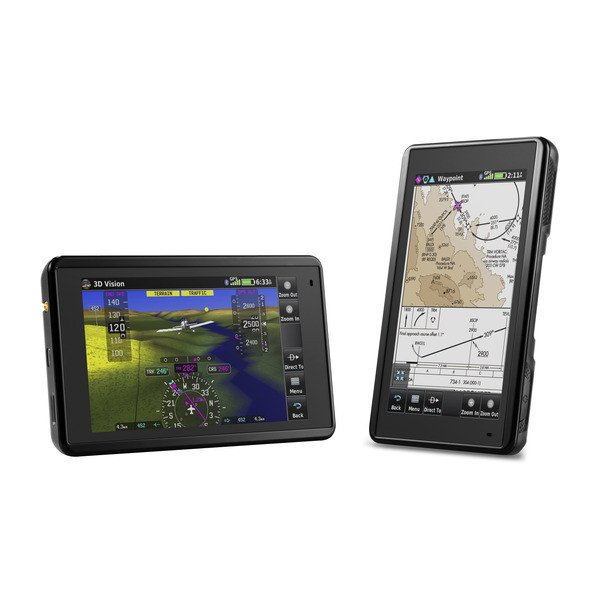
GARMIN AERA 660 Portable GPS Navigator
Product no.: 010-01518-01Available
Available delivery methods: Zone 1 EU - DHL, Zone 3 - DHL, Zone 4 - DHL, Zone 5 - DHL, Zone 6 - DHL, Inland - DHL, Pick up at AIR Store Walldorf, Zone 2 - DHL, Inland - DPD Hazardous Goods, Zone 7 - DPD Hazardous Goods, Zone 3 EU - DHL, Zone 1 - DHL
Advanced capabilities in a portable system
Rugged, portable navigation device with built-in GPS/GLONASS receiver and sunlight-readable 5" screen.
Intuitive, simple touchscreen operation and a single power switch make using the display a breeze
3D vision perspective shows terrain, obstacles, airport environment, optional traffic, nearest airport and more
Wireless cockpit connectivity via Connext® streams weather and traffic from compatible devices
Wi-Fi® database downloads and Garmin's low-cost navigation database help you lower database prices
Awareness in the palm of your hand
The aera 660 Aviation Portable puts the latest Garmin technology in the palm of your hand, and it continues our tradition of creating innovative navigation devices dating back to the early days of portable aviation GPS units. While the aera 660 is lightweight, compact and fits in any flight bag, it's still packed with features. As a stand-alone navigation device, it quickly and reliably acquires GPS and GLONASS satellite systems and combines advanced navigation tools with rich, interactive, dynamically drawn aeronautical charts. The unit displays all this on a bright, sunlight-readable 5-inch touchscreen display.
The icons on the aera 660 are instantly familiar to anyone who has used a Garmin GTN™ touchscreen GPS/NAV/COMM, an integrated G5000® Cockpit or even the Garmin Pilot™ app, and the intuitive interface allows you to quickly navigate the map screen, zoom in and out and more. The on/off switch on the top gives you quick access to settings such as portrait or landscape orientation, volume and brightness.
Full flight maps
The aera 660 Aviation Portable comes preloaded with detailed flight charts, terrain and obstacle warnings, US, European and Canadian SafeTaxi® charts and the AOPA Airport Directory or optional AC-U-KWIK Global Airport Directory to provide you with a variety of information - including local fuel prices (US only). The graphical terrain page provides both a plan view and a vertical profile view of the topography below you. Switch to IFR map mode to view and navigate high or low enroute airways, and use your touchscreen map cursor to determine MEAs (Minimum Enroute Altitudes) and distances between intersections. The aera 660 even offers vertical navigation guidance (VNAV) to simplify en-route transitions.
With more than 650 parachute drop zones (US only), stay informed of special airspace activity and get 1-touch airspace information. Garmin Smart Airspace™ guidance conveniently highlights the airspace closest to your current altitude and de-emphasises irrelevant airspace, so you can quickly see your position relative to the airspace around you. Of course, the aera 660 also includes our proprietary direct approach and nearest airport navigation.
Connect to your panel
With an optional power/data cable (sold separately), the aera 660 connects to your Garmin avionics to receive flight plans from your GTN 750/650 and GNS 530W/430W navigation devices and transmit frequencies to the standby position of your GTR 200 Comm radio, GTR 225 Comm radio or GNC 255 NAV/COMM radio. It also provides your Garmin NAV/COMM radios with the GPS position source needed to find the nearest frequencies.
Weather and traffic without wires.
With Garmin Connext Bluetooth® technology, the aera 660 easily connects to compatible devices to reduce clutter in your cockpit and enhance your flying experience. With a Garmin GDL® 52 portable ADS-B/SiriusXM® receiver or GTX 345 all-in-one ADS-B transponder, you can access and display subscription-free ADS-B weather information¹ and advanced traffic alerts such as TargetTrendTM, relative motion tracking and TerminalTrafficTM so you are aware of potential conflicts in busy airspace. In addition, the aera660 allows you to wirelessly control Garmin VIRB® action cameras to start and stop recording and take photos.
Get 3D perspective
Revolutionary 3D Vision technology gives you a virtual 3D perspective of the surrounding terrain ,even behind the aircraft, generated by GPS/GLONASS and the on-board terrain database. Swipe your finger across the touchscreen to rotate the view and display land and water areas, obstacles, runways and airport signage relative to the aircraft. When you connect the aera 660 to a flight attitude source via a Flight Stream 210 or Flight Stream 510, GDL 52 series portable data link or GTX 345 ADS-B transponder, Garmin SVX Synthetic Vision and flight attitude command bars are automatically added to your display.
In addition, with its predictive terrain avoidance feature, the Aera 660 can predict where towers or obstacles may be present and shade the map with yellow or red overlays to highlight these areas. Also get help avoiding hazards with Garmin WireAware™ Wire-Strike Avoidance technology, which features HOT (Hazardous Obstacle Transmission) lines spanning rivers and canyons. These are graphically highlighted directly on the map, both in the US and in some locations in Canada and Mexico. Touch the line trace to see both MSL and AGL elevations, and see a colour-coded obstacle warning depending on the distance to the hazard zone. A full database containing all high voltage lines is also available as an option.
Stay up to date with Garmin
With the aera 660, you can cut the wires - and your database prices. You can update databases over Wi-Fi instead of connecting to a computer, and stay up to date year-round with a single, affordable annual subscription that includes all the databases you need, including the Garmin navigation database (US, Canada and Mexico only).
All-in-one functionality
The aera 660 fulfils the role of either a Class I or Class II electronic flight bag, greatly reducing the need to rely on paper charts in the cockpit. Georeferenced VFR sectional charts and IFR route charts for the USA are pre-installed and show your aircraft's position directly on the appropriate chart. European and Canadian VFR and IFR charts as well as airport charts are also optionally available.
In IFR chart mode, the aera 660 can display vector flight paths, jet routes, leg distances and more, similar to conventional en-route charts. In addition, pilots who prefer Jeppesen charts and diagrams can use the integrated ChartView feature, which uses Jeppesen's extensive library to provide global georeferenced charting capabilities. European users get enhancements to the VFR charts to see even more visual reference points, including borders, lakes, roads, grasslands, parks and more.
Accessories
| Product | Note | Status | Price | ||
|---|---|---|---|---|---|
|
|
99.00 € * | |||
|
|
119.00 € * | |||
|
|
109.00 € * | |||
|
|
79.00 € * | |||
|
*
Display accessory details
Prices incl. VAT, plus shipping
|
|||||
 Garmin holding cradle incl. cableling with bare wires for aera 660 (aviation mounting)
Browse these categories as well: GPS Navigation, GPS Navigation, Devices
Hotline and Contact
Our expert support team is happy to help you with
your questions. We are all pilots and strive hard
to find the best and most affordable solutions for
our customers.
Phone: +49 6224 98 96 998
From April 15th to April 19th, our phone hotline is not available due to attendance at AERO Friedrichshafen Tradeshow.
eMail: support@air-store.eu
![]()